
Where We Came From
Ruzhin, Ukraine

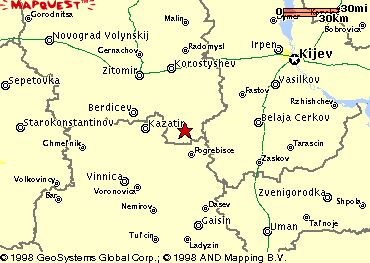
Ruzhin (49.30 latitude, 29.14 longitude) is located in Zhitomirskaya, 109 SE of Zhitomir, 58 km East of Berdichev, 75 km NE of Vinnitsa and 121.3 Km SW of Kiyev. The present town population is 5,001 - 25,000 with fewer than 10 Jews.
Jews probably settled in the early 18th century. In 1897, their population was 3,599 (total 5,016). Rabbi Yisrael of Ruzhin founded a local Hasidic dynasty that spread to Bukovina and Galicia . In a 1919 pogrom, Jews were robbed and beaten and a large tribute was exacted from the community. The Jewish population dropped to 1,108 in 1939. The Germans captured the town on 16 July 1941. On 10 September 1941 750 Jews were taken to Mt. Karchev and executed with the participation of Ukrainian police; 250 skilled Jewish workers were left behind. Valuables were stolen and a large tribute was extorted from the community towards the end of the year. On 1 May 1942 another 500 Jews were murdered. (excerpt from The Encyclopedia of Jewish Life. Before and During the Holocaust. Editor in Chief Shmuel Spector Published by Yad Vashem, Jeruslaem and New York University Press, 2001 )
There are three cemeteries in Ruzhin where undoubtedly many of our relatives are buried including those murdered during the Shoah [Holocaust].
RUZHIN I - The Jewish cemetery was established in the 18th century with last known Jewish burial 1993. No other towns or villages used this unmarked cemetery. The isolated urban hillside has no sign or marker. Reached by turning directly off a public road, access is open to all. No wall, fence, or gate surrounds site. 501 to 5000 stones, most in original location with 25% - 50% toppled or broken, date from 1776. The cemetery has special sections for men and women. Some tombstones have traces of painting on their surfaces, portraits on stones and/or metal fences around graves. The cemetery contains no known mass graves. Municipality owns site used for Jewish cemetery only. Properties adjacent are agricultural and residential. The cemetery boundaries have not changed since 1939. Rarely, Jewish or non-Jewish private visitors and local residents visit. The cemetery was vandalized occasionally in the last ten years. There is no maintenance now. Within the limits of the cemetery are no structures.
RUZHIN II - In 1941, the synagogue was closed and the Jewish mass grave was dug. Jews from no other towns or villages were murdered at this unmarked mass grave. The isolated rural (agricultural) flat land has no sign or marker. Reached by turning directly off a public road, access is open to all. A continuous fence with no gate surrounds the mass grave. 1 to 20 common tombstones, all in original location with none toppled or broken, date from 1967. The site contains marked mass graves. Municipality owns property used for mass burial site. This mass grave was not vandalized. Within the limits of the mass grave are no structures.
RUZHIN III - The mass grave is located 2 km from village. The Hasidic mass grave was dug in 1941. Jews from no other towns or villages were murdered at this unmarked mass grave. The rural (agricultural) flat land, separate but near other cemeteries, has no sign or marker. Reached by crossing municipal cemetery, access is open to all. A continuous fence with no gate surrounds the mass grave. 1 to 20 stones, all in original location with none toppled or broken, date from 1960. No stones were removed. Some tombstones have metal fences around graves. The site contains marked mass graves. Municipality owns property used for mass burial site. This mass grave was not vandalized. Jewish individuals within country did re-erection of stones in 1960. Within the limits of the mass grave are no structures.